Anonymous Data
Sep 30, 2019
Several stakeholders have expressed interest in publicly sharing anonymous power plant data in the Solar Forecast Arbiter. While the Arbiter does not explicitly support anonymous data exchange, we can provide some recommendations for how to use the Arbiter’s features to accomplish this goal. Please keep in mind that these are only recommendations for how to conceal plant identity – they do not guarantee anonymity! It is solely the user’s responsibility to provide enough information about the plant to be useful, but not so much as to reveal its identity.
Location
The first challenge for making a plant anonymous is determining how to specify its location. Forecast techniques that rely on numerical weather models or satellite data need to know plant location with a reasonable degree of accuracy. On the other hand, the plant location must be sufficently vague so as to make it impossible to determine which of many plants it may be within a region. Regions with only a few plants therefore require specification of less precise coordinates than regions with many plants. Clicking around Google Maps or Google Earth are easy ways to find suitable coordinates. We also recommend that users make a note in the extra parameters metadata field to indicate that the metadata describes an anonymous plant in the region.
The xkcd comic below provides some practical guidance on what the digits of latitude and longitude coordinates specify:
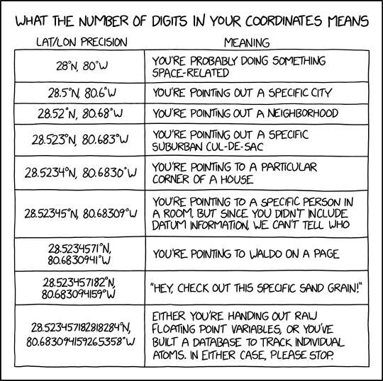
For day ahead forecasts in most locations, one degree is likely too coarse, but a tenth of a degree may be precise enough. Additional care must be taken in areas of varying topography. For example, avoid specifying plant locations that are at higher or lower elevations than the true location. Also, avoid specifying locations on lakes or oceans. Don’t specify a location that already has another solar plant on it – that’s unnecessarily confusing and could lead to issues with the other plant owners/operators.
For intraday forecasts, a tenth of a degree may not be precise enough. Carefully consider the compromises when pursuing intraday forecasts for anonymous plants.
Forecast techniques that only use plant data (e.g. persistence) do not need location data unless they include corrections based on solar position (e.g. persistence of clear sky index). For this reason, we still recommend specifying coordinates to about a tenth of a degree.
Data normalization
Anonymous plant data should be normalized so that the AC power output cannot be determined and cross-referenced with publicly available power plant data (e.g. from eia.gov). We recommend normalizing data to the AC capacity of the plant. In this case, the uploaded generation data would all fall between 0 (no generation) and 1 (generation = AC capacity). Specify the plant metadata with an AC capacity of 1. Take some care in specifying the corresponding DC capacity because an exact DC:AC ratio could allow someone to identify the plant. There’s no point in trying to hide the tracker vs. fixed tilt selection – it will be obvious in the data. However, it’s prudent to round the axis tilt and azimuth of a fixed tilt system to 5 degrees or so (e.g. if the true tilt/azimuth are 26/179 degrees, round them to 25/180 degrees).
Aggregation
Another method to conceal plant generation is to only include its generation data as part of an aggregate of many plants. This strategy may be used to represent generation from a fleet of PV plants or a neighborhood of rooftop PV installations. Depending on the use case, it may still be desirable to provide exact metadata for the constituent plants. In either case, a new Site is created that represents the aggregate of all of the plants (exact metadata is irrelevant), an AC power Observation is attached to the Site, and user-aggregated generation data is uploaded. More information on the Arbiter’s built-in aggregation capabilities will be provided soon.